
|
|
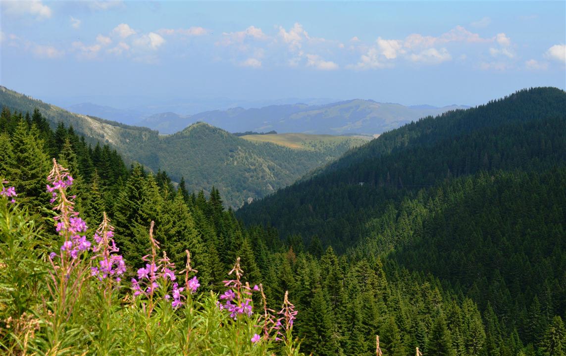
TARA NATIONAL PARK

Banjska Stena - Viewpoint
Tara (SerbianCyrillic: Тара, pronounced [târa]) is a mountain located in western Serbia. It is part of Dinaric Alps and stands at 1,000 to 1,590 m (3,280 to 5,220 ft) above sea level. The mountain's slopes are clad in dense forests with numerous high-altitude clearings and meadows, steep cliffs, deep ravines carved by the nearby Drina River and many karst, or limestone caves. The mountain is a popular tourist centre. Tara's national park encompasses a large part of the mountain. The highest peak is Zborište, at 1,544 m (5,066 ft).
Read more.... Tara (mountain) - Wikipedia |
The distance from Belgrade is about 251 klm. Approximate time 3h:21m by car.
These instructions are for intended purposes only. You may find that conditions differ from the map results due to construction, traffic, old conditions or other events, so you should plan your route accordingly. You must obey any signs or warnings that concern your route. VIEWPOINTSContact Information
Address: Milenka Topalovića 3 Bajina Bašta, Serbia Phone: (+381) 031/ 863 644 E-mail: [email protected] [email protected] Web address: https://www.nptara.rs/en/ |
Djerdap National Park

Image is from Wikipedia
Đerdap National Park (Serbian: Национални парк Ђердап / Nacionalni park Đerdap) stretches along the right bank of the Danube River from the Golubac Fortress (Serbian: Голубачки град / Golubački grad) to the dam near Novi Sip, Serbia. It was established in 1974 and spreads on 63,786.5 ha (157,620 acres).The park management office is in the town of Donji Milanovac on the Danube. Across the river is the Parcul Natural Porțile de Fier in Romania.
In July 2020 the wider area of the national park was designated as the UNESCO global geopark, as the first protected area from Serbia labeled that way. Apart from the Iron Gates Gorge, the geopark includes parts of the Miroč and Kučaj mountain massifs, with total area of 1,330 km2 (510 sq mi). Read more... Đerdap National Park - Wikipedia |
The distance from Belgrade is about 129 klm. Approximate time 1h:46m by car.
These instructions are for intended purposes only. You may find that conditions differ from the map results due to construction, traffic, old conditions or other events, so you should plan your route accordingly. You must obey any signs or warnings that concern your route. Contact Information
Address: Public Enterprise Djerdap National Park st. Kralja Petra I No. 14a 19220 Donji Milanovac, Serbia Phone: Visitor center – Donji Milanovac +381 (0)30 215 0088 E-mail: [email protected] Web address: https://npdjerdap.rs/en/ |
Fruška Gora National Park

Odmaraliste Zmajevac na FG, Author: Jovancavic
Fruška gora (Serbian Cyrillic: Фрушка гора; Hungarian: Tarcal-hegység) is a mountain in Syrmia, administratively part of Serbia with a part of its western side extending into eastern Croatia. The area under Serbian administration forms the country's oldest national park. Sometimes it's also referred to as the Jewel of Serbia, due to its largely pristine landscape and protection effort, or the Serbian Mount Athos, it being the home of a large number of historical Serbian Orthodox monasteries. The national park of Fruška Gora was declared in 1960 and covers an area of 266.72 km2 (102.98 sq mi). It is the oldest modern national park in Serbia.
Read more…. Fruska gora - Wikipedia *Soon we will have new photos
|
The distance from Belgrade is about 84,2 klm. Approximate time 1h:9m by car.
These instructions are for intended purposes only. You may find that conditions differ from the map results due to construction, traffic, old conditions or other events, so you should plan your route accordingly. You must obey any signs or warnings that concern your route. Contact Information
Address: Dragon Square 1 21208 Sremska Kamenica Phone: +381 21 463 666 E-mail: [email protected] Web address: https://www.npfruskagora.co.rs/lat/ |
Kopaonik National Park
Kopaonik, Author: Olja Simović
Kopaonik (Serbian Cyrillic: Копаоник, pronounced [kɔpaɔ̌niːk]; Albanian: Kopaoniku) is a mountain range located in Serbia and Kosovo. The highest point is the Pančić's Peak with 2,017 m (6,617 ft). The central part of the Kopaonik plateau was declared a national park in 1981 which today covers an area of 121.06 km2 (46.74 sq mi).
On the slopes of mountain range there is a Kopaonik ski resort which is one of the largest in Southeast Europe. There are 25 ski lifts with capacity of 32,000 skiers per hour. Stretching for 75 km (47 mi) in the north-south direction, between the rivers of Lab and Sitnica on the south and Jošanica on the north, Kopaonik is one of the largest and longest mountains in Serbia. It belongs to the region of Raška. The Kopaonik mountain massif (Kopaoničke planine) includes the mountains of Kopaonik, Željin, Goč and Stolovi. The Pančić's Peak, with 2,017 m (6,617 ft), is the highest point of the mountain. *Soon we will have new photos
|
The distance from Belgrade is about 278 km. Approximate time 3h:52m by car.
These instructions are for intended purposes only. You may find that conditions differ from the map results due to construction, traffic, old conditions or other events, so you should plan your route accordingly. You must obey any signs or warnings that concern your route. Contact Information
Contact of the Kopaonik ski center (information about slopes and installations) Phone: +381 (36) 5471-203 (info cable cars), Phone: +381 (36) 5471-211, 5471-209 (info ski pas), Fax: +381 (36) 5471-204 Health center: 036/5471-094 Police: 036/5471-092 Fire department: 036/5471-977 ext. 1600 Mountain rescue service: 063/466-466 Trauma center: 018/509-221 Web address: https://www.kopaonik.rs/kopaonik-mountain-resort/ |
Sicevac Gorge

Sićevačka klisura vidikovac , Author: DjordjeMarkovic
The Sićevo Gorge (Serbian: Sićevačka klisura; Serbian Cyrillic: Сићевачка клисура, pronounced [sîtɕɛʋatʃkaː klǐsura]), a river gorge and archaeological site in southeastern Serbia, is the locally most prominent geological and topographic feature formed by the Nišava River. The gorge is located between the towns of Bela Palanka and Niška Banja. It is 17 km (11 mi) long and 350 to 400 m (1,150 to 1,310 ft) deep, in some parts developing canyon-like structures (including the inverse valley slopes at the Gradiški kanjon). The gorge is cut into the Kunovica plateau, between the southern slopes of the Svrljig Mountains and the mountain of Suva Planina. The surrounding areas are known for their high-quality vineyards. The gorge contains a stone quarry, the Ostrovica and six villages. The largest, Sićevo is the eponym of the gorge.
Read more…. Sićevo Gorge - Wikipedia * Soon we will have new photos
|
The distance from Belgrade is about 265 klm. Approximate time 2h:59m by car.
These instructions are for intended purposes only. You may find that conditions differ from the map results due to construction, traffic, old conditions or other events, so you should plan your route accordingly. You must obey any signs or warnings that concern your route. |
Mokra gora - Sergan

JZ-83-173 mokragora2 , Author: Herbert Ortner, Vienna, Austria
Mokra Gora (Serbian Cyrillic: Мокра Гора; pronounced [mɔ̝̂kraː ɡɔ̝̌ra]), meaning the Wet Mountain in English, is a village located in the city of Užice, southwestern Serbia. It is situated on the northern slopes of mountain Zlatibor. Emphasis on historical reconstruction has made it into a popular tourist center with unique attractions.
Read more… Mokra Gora - Sergan - Wikipedia *Soon we will have new photos
|
The distance from Belgrade is about 247 klm. Approximate time 3h:2m by car.
These instructions are for intended purposes only. You may find that conditions differ from the map results due to construction, traffic, old conditions or other events, so you should plan your route accordingly. You must obey any signs or warnings that concern your route. Contact Information
Sargan Eight Reservation Telephones: Central booking: +381 31 510 188 Railway station Mokra Gora: +381 31 800 003 Timetable of the Sargan Eight: From Apr 1 until Oct 31 10:30 AM, 1:30 PM, 4:10 PM (from July 1 to Aug 31) Cost fo Sargan Eight: 600 dinars for adults, 300 dinars for children (6 to 14 years old). Contact for Drvengrad: +381 31 800 686, +381 64 88 30 213, Web site: www.mecavnik.info, E-mail: [email protected] Drvengrad entrance ticket: 250 dinars. |
Resava Cave

Mother with child in Resava cave , Author: Antidiskriminator
Resava Cave (Serbian: Ресавска пећина, romanized: Resavska pećina) or Resavska Cave is a cave near Jelovac in eastern Serbia, about 20 kilometres (12 miles) from Despotovac. It is one of the largest cave systems in Serbia, with the corridors about 4.5 kilometres (2.8 miles) long.
The cave is located in the Upper Resava region. The cave is estimated to be 80 million years old while the oldest speleothems date from 45 million years ago. It has four halls on two levels each and the speleothems are colored in red, yellow and white. Altitude at the entrance into the cave is 485 metres (1,591 feet) and the lowest point inside is at 405 metres (1,329 feet). The cave was formed by the sinking river in the limestone substrate. Cave formations are right at the entry. They are formed through the dissolving of the calcium carbonate. The color depends on the mineral through which the water flows: red from the iron oxide, white from the crystallized calcium and yellow from the traces of clay. The symbol of the cave is a massive stalagmite, 20 m (66 ft) tall and 12 m (39 ft) wide. After its appearance, it was named the Statue of mother with a child. The cave consists of 8 halls. Read more…. Resava Cave - Wikipedia *Soon we will have new photos
|
The distance from Belgrade is about 154 klm. Approximate time 2h:4m by car.
These instructions are for intended purposes only. You may find that conditions differ from the map results due to construction, traffic, old conditions or other events, so you should plan your route accordingly. You must obey any signs or warnings that concern your route. |
Stopića Cave
|
Stopića Cave (Serbian: Стопића пећина, romanized: Stopića pećina) is a limestone cave near Sirogojno, on the slopes of Mount Zlatibor in western Serbia. It has been protected by the state as the natural monument.
The Stopića Cave is located on the territory of the Rožanstvo village. It is situated 19 km (12 mi) from Zlatibor, in the Sirogojno direction. The location where to turn from the road between two villages is marked by the representation of the large bottle, posted as the commercial for the former Vapa Spa. Read more…. Stopića Cave - Wikipedia |
The distance from Belgrade is about 219 klm. Approximate time 2h:52m by car.
These instructions are for intended purposes only. You may find that conditions differ from the map results due to construction, traffic, old conditions or other events, so you should plan your route accordingly. You must obey any signs or warnings that concern your route. |
Important Notice: The information for each destination is taken from Wikipedia


